
All programs › BMPFast › Sample problems
Routing: wet ponds in series (2020 manual)
BMPFast sample project: three catchments, each with a wet pond, routed in series.
Help: Routing (help page 220) · Download the .bmpt · Link to Solution in BMPFast Version 2
1The problem
The BMPFast sample project Detention in series, 2020 TAC manual page 194: three catchments in Zone 4, each with its own wet detention pond, drain one into the next. In this copy only the upstream pond has a littoral zone, as the credit counts once in a series.
| Input | Value | Source |
|---|---|---|
| Project (General Site Information) | ||
| Meteorological zone | Florida Zone 4 | Zone map (help page 815) |
| Mean annual rainfall | 52 in | Mean annual rainfall map (help page 815) |
| Performance standard (analysis type) | All sites non-exempted | BMPFast sample project |
| Catchment 1: upstream one (Watershed Characteristics) | ||
| Land use, pre / post | Agricultural - Citrus / User Defined Values | BMPFast sample project |
| Area, pre / post | 20.75 / 20.75 ac | BMPFast sample project |
| Non-DCIA curve number, pre / post | 68.3 / 76.12 | BMPFast sample project |
| DCIA, pre / post | 0 / 17.9 % | BMPFast sample project |
| EMC TN, pre / post | 2.110 / 1.816 mg/L | BMPFast land use table (AH Vol I Table 9.2) |
| EMC TP, pre / post | 0.180 / 0.453 mg/L | BMPFast land use table (AH Vol I Table 9.2) |
| Wet pond area (no loading) | 0.79 ac | BMPFast sample project |
| BMP used in routing | Wet Detention: permanent pool 1 ac-ft; Check if there is a littoral zone ticked; MAPs credit 0 % | BMPFast sample project |
| Routes to | Catchment 2 | BMPFast sample project |
| Catchment 2: Catchment 2 (Watershed Characteristics) | ||
| Land use, pre / post | Agricultural - Citrus / User Defined Values | BMPFast sample project |
| Area, pre / post | 25.13 / 25.13 ac | BMPFast sample project |
| Non-DCIA curve number, pre / post | 68.3 / 76.12 | BMPFast sample project |
| DCIA, pre / post | 0 / 17.8 % | BMPFast sample project |
| EMC TN, pre / post | 2.110 / 1.715 mg/L | BMPFast land use table (AH Vol I Table 9.2) |
| EMC TP, pre / post | 0.180 / 0.407 mg/L | BMPFast land use table (AH Vol I Table 9.2) |
| Wet pond area (no loading) | 1.55 ac | BMPFast sample project |
| BMP used in routing | Wet Detention: permanent pool 1.25 ac-ft; Check if there is a littoral zone unticked; MAPs credit 0 % | BMPFast sample project |
| Routes to | Catchment 3 | BMPFast sample project |
| Catchment 3: Catchment 0 (Watershed Characteristics) | ||
| Land use, pre / post | Agricultural - Citrus / User Defined Values | BMPFast sample project |
| Area, pre / post | 37.41 / 37.41 ac | BMPFast sample project |
| Non-DCIA curve number, pre / post | 68.3 / 84 | BMPFast sample project |
| DCIA, pre / post | 0 / 19 % | BMPFast sample project |
| EMC TN, pre / post | 2.110 / 1.816 mg/L | BMPFast land use table (AH Vol I Table 9.2) |
| EMC TP, pre / post | 0.180 / 0.453 mg/L | BMPFast land use table (AH Vol I Table 9.2) |
| Wet pond area (no loading) | 1.70 ac | BMPFast sample project |
| BMP used in routing | Wet Detention: permanent pool 2.5 ac-ft; Check if there is a littoral zone unticked; MAPs credit 0 % | BMPFast sample project |
| Routes to | the Outlet | BMPFast sample project |
Find: the loads leaving the site when the catchments are routed through each other, and how BMPFast treats the chain.
2Steps in BMPFast
Press Open Project and open
routing-detention-in-series.bmpt(the file under Files; it is the BMPFast sample project Detention in series one littoral zone.bmpt (a copy of Detention Multiple catchments 2020 Manual pages 190 196.bmpt)). General Site Information (the main window; its title bar reads General Site Information and your license key) shows Florida Zone 4, 52.0 in of rainfall and the performance standard All sites non-exempted.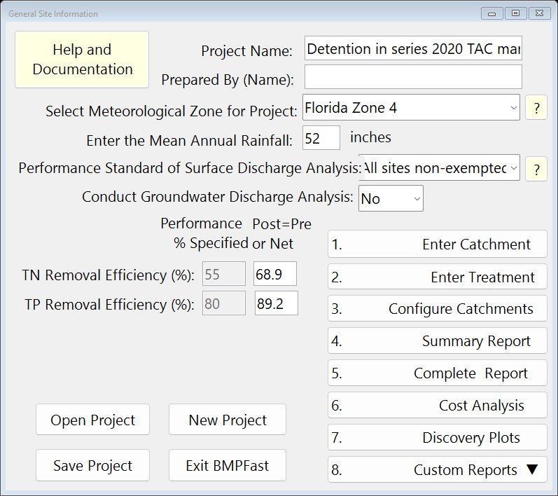
General Site Information (the main window). Press 1. Enter Catchment and click Catchment 1 in the menu bar at the top of the Watershed Characteristics Worksheet. It holds: name upstream one; land uses Agricultural - Citrus (pre) and User Defined Values (post); areas 20.75 and 20.75 ac; non-DCIA CN 68.3 and 76.12; DCIA 0 and 17.9 %. Press Back.
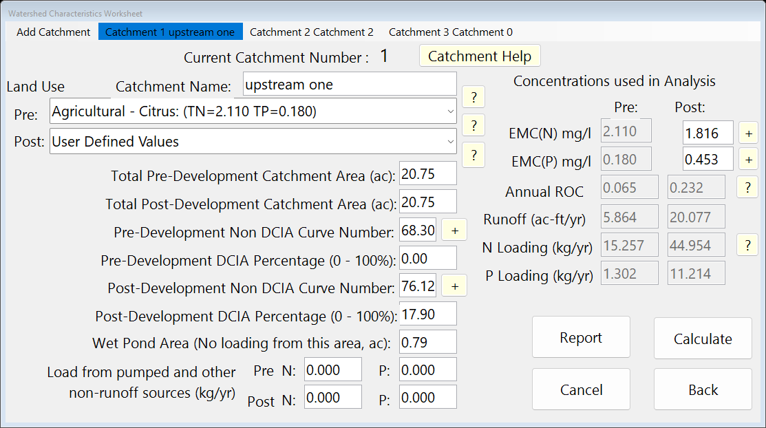
Watershed Characteristics, Catchment 1. On the Watershed Characteristics Worksheet click Catchment 2 in the menu bar: name Catchment 2; land uses Agricultural - Citrus (pre) and User Defined Values (post); areas 25.13 and 25.13 ac; non-DCIA CN 68.3 and 76.12; DCIA 0 and 17.8 %.
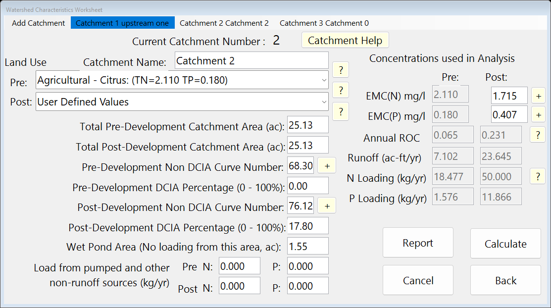
Watershed Characteristics, Catchment 2. On the Watershed Characteristics Worksheet click Catchment 3 in the menu bar: name Catchment 0; land uses Agricultural - Citrus (pre) and User Defined Values (post); areas 37.41 and 37.41 ac; non-DCIA CN 68.3 and 84; DCIA 0 and 19 %.
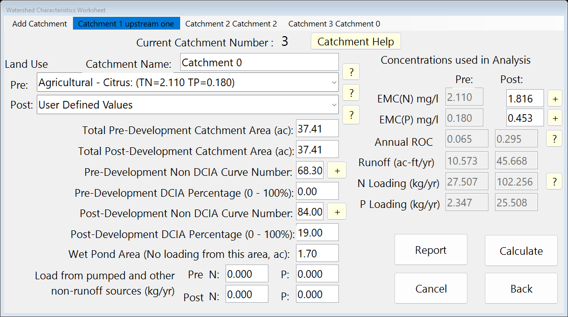
Watershed Characteristics, Catchment 3. Press 2. Enter Treatment, click Catchment 1 in the menu bar to make it current, and press Wet Detention to see its BMP: permanent pool 1 ac-ft; Check if there is a littoral zone ticked; MAPs credit 0 %. Press Calculate, then Back.
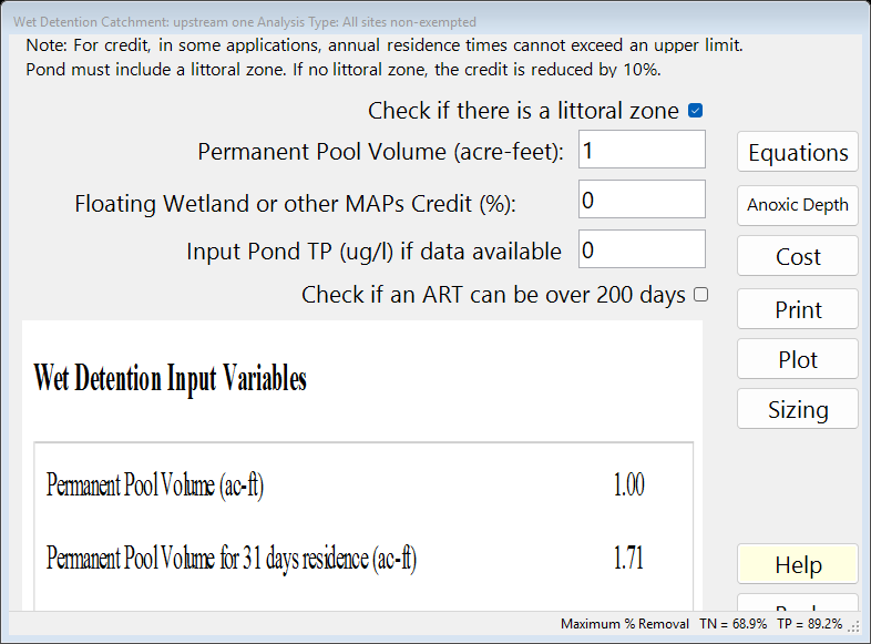
The BMP worksheet after Calculate: the report on the left. Press 2. Enter Treatment, click Catchment 2 in the menu bar to make it current, and press Wet Detention to see its BMP: permanent pool 1.25 ac-ft; Check if there is a littoral zone unticked; MAPs credit 0 %. Press Calculate, then Back.
Press 2. Enter Treatment, click Catchment 3 in the menu bar to make it current, and press Wet Detention to see its BMP: permanent pool 2.5 ac-ft; Check if there is a littoral zone unticked; MAPs credit 0 %. Press Calculate, then Back.
On the main window press 3. Configure Catchments. in the row of Catchment 1 press Edit (the Routing Catchment From: 1 window opens). In Select BMP to use in routing choose Wet Detention; in Select Catchment to Route to choose Catchment 2. Press Back.
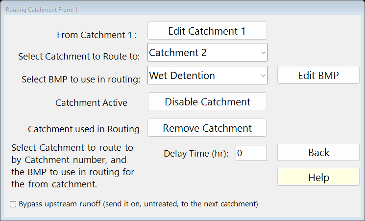
Routing for Catchment 1. Back on Select Catchment Configuration, in the row of Catchment 2 press Edit (the Routing Catchment From: 2 window opens). In Select BMP to use in routing choose Wet Detention; in Select Catchment to Route to choose Catchment 3. Press Back.
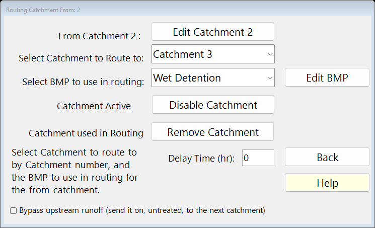
Routing for Catchment 2. Back on Select Catchment Configuration, in the row of Catchment 3 press Edit (the Routing Catchment From: 3 window opens). In Select BMP to use in routing choose Wet Detention; in Select Catchment to Route to choose the Outlet. Press Back (Back again closes Select Catchment Configuration).
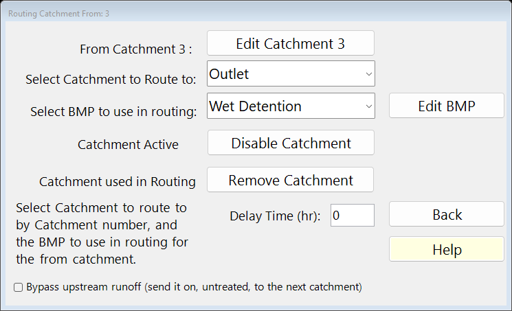
Routing for Catchment 3. Select Catchment Configuration now lists every catchment: From, To (0 is the Outlet), area and the BMP used.
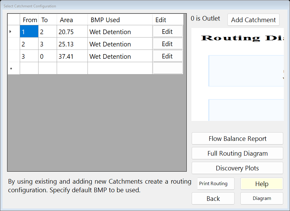
Select Catchment Configuration (3. Configure Catchments). Press Diagram to see the network.
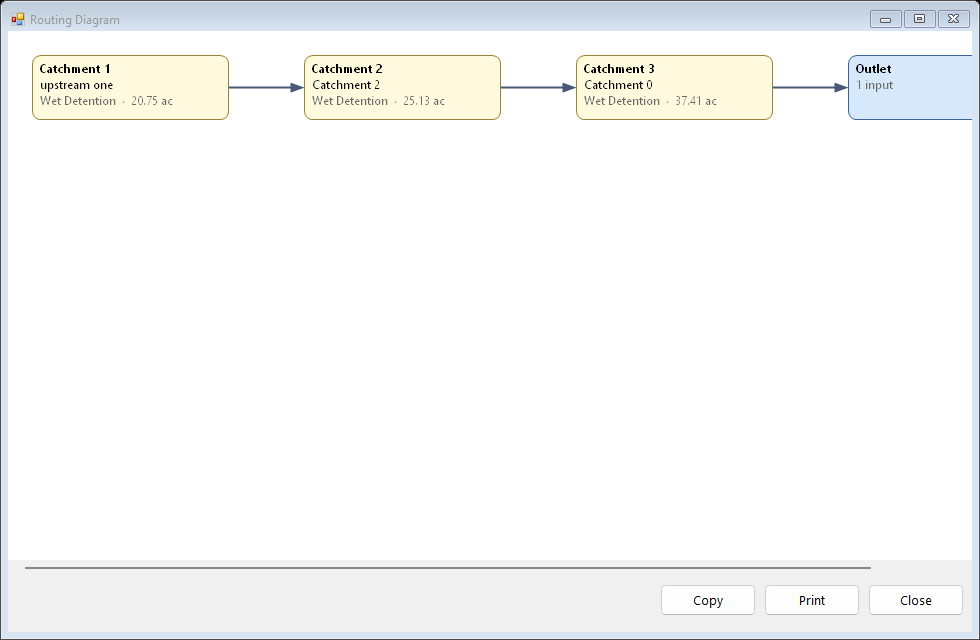
The routing Diagram. Press Full Routing Diagram for the routing report: each strand and the method used. Press Back.
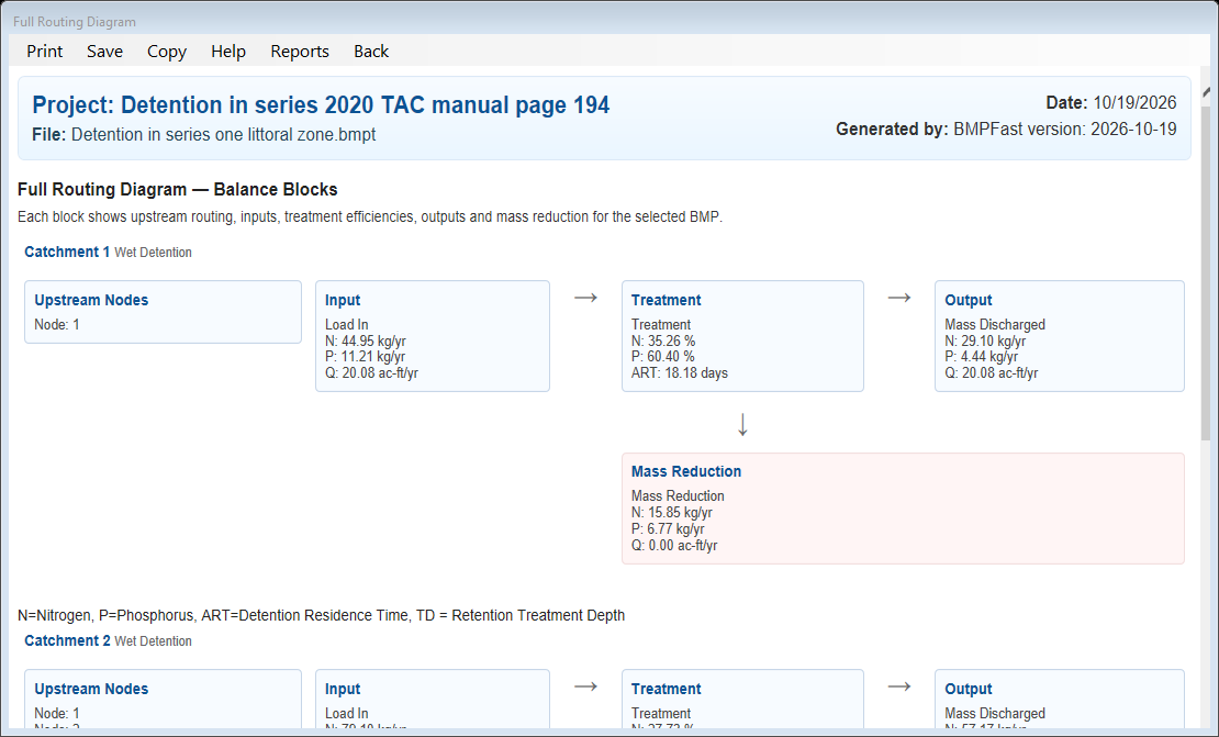
The Full Routing Diagram report. Press 4. Summary Report. The Report Viewer shows the loads, the removal and whether the performance standard is met. Press Save Project to keep your copy; compare it with the .bmpt under Files.
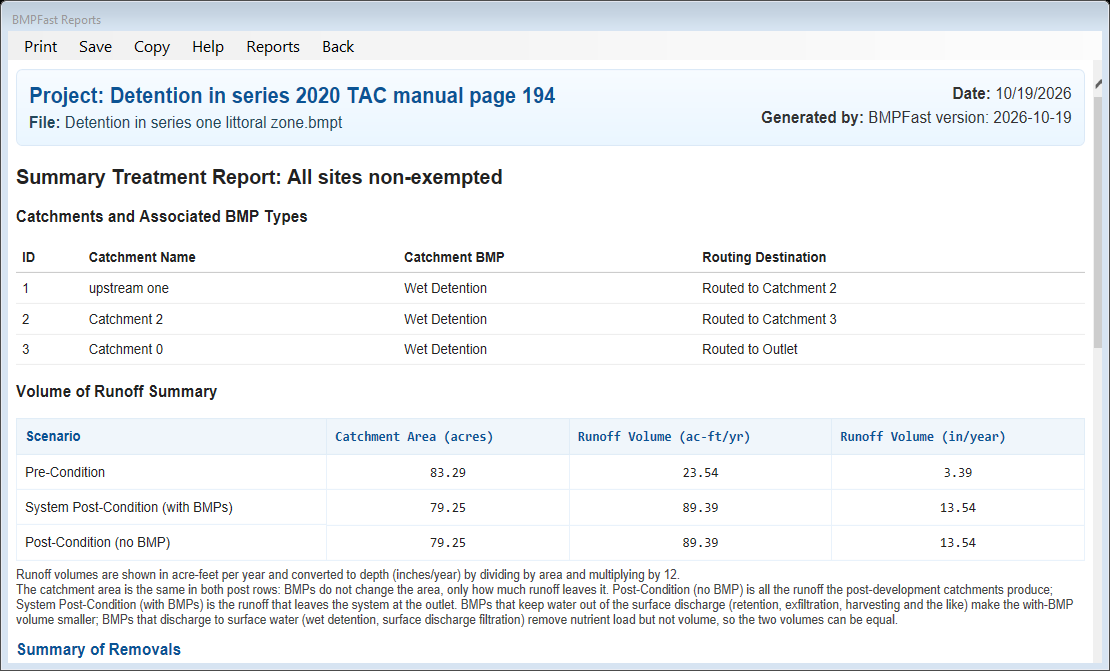
The Summary Report (4. Summary Report) in the Report Viewer.
3Results
| Catchment | Runoff (ac-ft/yr) | TN load (kg/yr) | TP load (kg/yr) | BMP → routes to |
|---|---|---|---|---|
| 1. upstream one | 20.077 | 44.954 | 11.214 | Wet Detention → Catchment 2 |
| 2. Catchment 2 | 23.645 | 50.000 | 11.866 | Wet Detention → Catchment 3 |
| 3. Catchment 0 | 45.668 | 102.256 | 25.508 | Wet Detention → the Outlet |
| Result | Value |
|---|---|
| Site (all catchments, at the outlet) | |
| TN load: catchments → outlet | 197.210 → 115.496 kg/yr |
| TP load: catchments → outlet | 48.587 → 16.621 kg/yr |
| Provided removal TN / TP | 41.4 % / 65.8 % |
| Required removal TN / TP (Maximum % Removal) | 68.9 % (not met) / 89.2 % (not met) |
Strands found by BMPFast (a strand is a run of catchments in series that BMPFast may calculate as one system):
- Catchments 1 → 2 → 3 form one strand, “All Catchments are Detention in Series”: BMPFast calculates them as one system (TN in 197.210 kg/yr, removal 41.43 %, out 115.496 kg/yr).
The Full Routing Diagram report
Open this report on its own page.
The Summary Report
4Check
Loads.
Each catchment’s load is EMC × runoff × 1.233 (Equation 9-2). Together:
| TN 44.954 + 50.000 + 102.256 | = 197.210 kg/yr (program 197.210) |
TP 48.587 kg/yr (program 48.587).
Wet detention in series (the strand rule).
BMPFast finds the strand “All Catchments are Detention in Series” and calculates the ponds as one system: the permanent pools (4.75 ac-ft in all) and the runoff of the chain give one residence time, then the Appendix O pond equations give the system removal, TN 41.43 % and TP 65.79 %.
| TN out | = 197.210 × (1 − 41.43 / 100) |
| = 115.496 kg/yr (program 115.496). |
Only the upstream pond (Catchment 1) has its littoral zone box ticked: in a series of wet ponds the littoral zone credit counts once, on the most upstream pond (Ron Eaglin, October 19, 2026); ponds in parallel may each keep it. See Strand Based Routing for Wet Detention in Series and the comparison of methods for ponds in series.
The standard is not met, and that is expected. “All sites non-exempted” requires the greater of 55 % TN and 80 % TP, or the removal that keeps the post-development load at the pre-development load (Equation 9-3) (AH Vol I 8.3.2). The post = pre removal (Equation 9-3, (post load − pre load) / post load) is TN 68.9 % and TP 89.2 %. BMPFast takes the larger of the standard’s percentage and the post = pre removal as the Maximum % Removal, shown on every worksheet’s status bar and in the Summary Report: here TN 68.9 % and TP 89.2 %. This problem shows what this design removes (41.4 % / 65.8 %), which is less. To meet it, add BMPs in series or downstream catchments (see BMPs in Series and Routing), or size the BMP (see Sizing).
5Files
- routing-detention-in-series.bmpt: the project, saved by BMPFast. Save it (your browser puts it in Downloads). In BMPFast press Open Project, then Open Project again in the Open BMPFast Project dialog (below its Recent Projects list), and choose the file.
- Full Routing Diagram report (as BMPFast shows it)
- Summary Report (as BMPFast shows it)
6Help and methodology
- Routing (help page 220)
- Catchment Configurations (help page 196)
- Strand Based Routing for Wet Detention in Series (help page 4823)
- Strand Based Routing for Retention in Series (help page 4824)
- Strand Based Routing for No Treatment to Detention (help page 4833)
- Strand Based Routing for No Treatment to Retention (help page 4834)
- All sample problems
Calculated with BMPFast 1.1.9 (build 6.0.0, 2026-10-16). Older versions may not have the Equations button or may give slightly different results; download the latest at bmpfast.com. Screen captures are for demonstration only.