Studies: start, save and open
A study is one traffic puzzle: its roads and intersections, its traffic, and its challenge. Each study becomes one web page. This page covers how to start one, keep it, and pass it on.
The start screen
TrafficLab+ opens on the start screen. It says what the program is for, the four steps from an intersection to a link, and offers the ways in:
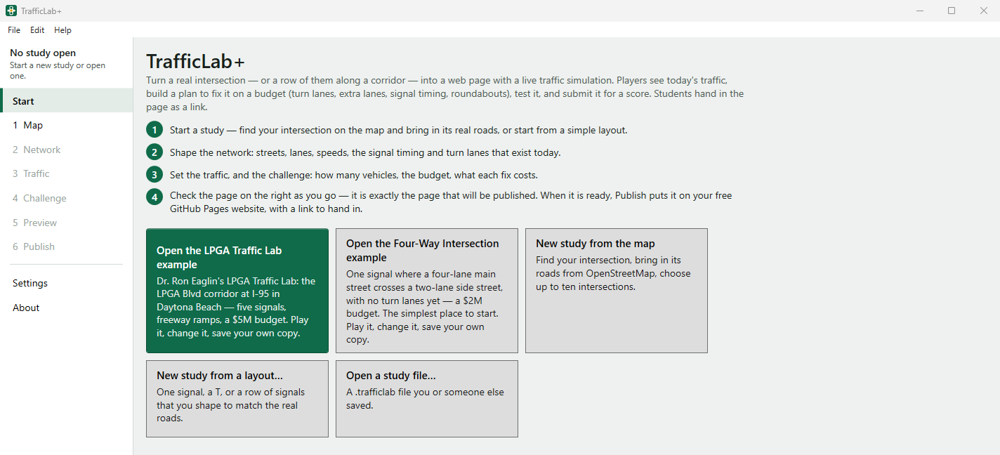
- Open the LPGA Traffic Lab example — five signals along LPGA Boulevard at I-95 in Daytona Beach, a $5M budget.
- Open the Four-Way Intersection example — one signal where a four-lane main street crosses a two-lane side street, with no turn lanes yet, a $2M budget. The simplest place to start.
- New study from the map — find your intersection and bring in its real roads from OpenStreetMap. See The Map.
- New study from a layout… — one signal, a T, or a row of signals that you shape to match the real roads.
- Open a study file… — a
.trafficlabfile you or someone else saved.
Studies you saved before are listed under Continue where you left off; click one to open it. You can come back to the start screen at any time: Start at the top left. If a study on that list has been moved or deleted, opening it says That file is gone; it has been taken off the list.
The built-in examples
The examples are finished studies to play, change and learn from. They are also under File ▸ Open an example. An example never changes: the left column says The built-in example. Save as… keeps your own copy. Every value in it is marked from the built-in example. To keep what you changed, use File ▸ Save as…; your copy is then your own study.
A new study from a simple layout
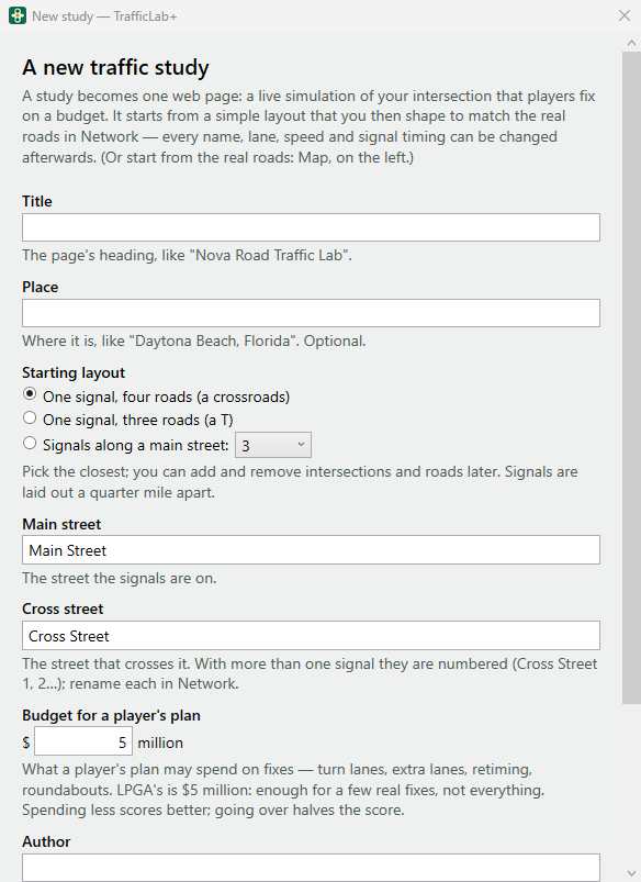
File ▸ New study… (Ctrl+N), or New study from a layout… on the start screen, opens A new traffic study:
| Box | What to put in it |
|---|---|
| Title | The page's heading, like "Nova Road Traffic Lab". Needed. |
| Place | Where it is, like "Daytona Beach, Florida". Optional. |
| Starting layout | One signal, four roads (a crossroads), One signal, three roads (a T), or Signals along a main street: with how many (2 to 10). Pick the closest; you can add and remove intersections and roads later. Signals are laid out a quarter mile apart. |
| Main street, Cross street | The street the signals are on, and the one that crosses it. With more than one signal the cross streets are numbered (Cross Street 1, 2…); rename each in Network. |
| Budget for a player's plan | In millions of dollars — what a player's plan may spend on fixes. Type 5, 3.5 or $3.5M (from 0.1 to 1000). LPGA's is $5 million: enough for a few real fixes, not everything. Spending less scores better; going over halves the score. |
| Author, Course | Your name for the page's credit line, and the class it is for. Both optional; set the usual ones in Settings and they are filled in for you. |
Press Create the study. The study opens in Network, where you shape it to match the real roads. Everything — every name, lane, speed and signal timing — can be changed afterwards. To start from the real roads instead, use the Map.
Saving and opening
- File ▸ Save (Ctrl+S) and File ▸ Save as… (Ctrl+Shift+S). Studies are saved in
Documents\TrafficLabPlus\Studiesunless you choose another place. - The left column says whether the study is saved: Not saved yet — File ▸ Save or Changes not saved yet (Ctrl+S). A • in the window title means unsaved changes.
- File ▸ Open a study file… (Ctrl+O) and File ▸ Open recent. File ▸ Close the study closes it.
- Before anything would lose your changes (opening another study, closing the program), TrafficLab+ asks Save the changes to "…" first? — Yes saves, No throws them away, Cancel goes back.
The .trafficlab file
A .trafficlab file holds the whole study: the study itself, your notes, and — for a study made from the map — the roads as
OpenStreetMap gave them and any FDOT counts you looked up. So a saved study never has to ask OpenStreetMap or FDOT again, and works offline.
Handing out a study: an instructor can give the class a .trafficlab file (by email, the learning system, a shared
drive). Each student opens it with Open a study file…, saves their own copy, and works from there. TrafficLab+ also opens a
study saved as plain .json; it is then saved as a .trafficlab file.
Undo, and the yellow bar
- Edit ▸ Undo (Ctrl+Z) undoes any change to the study, and Edit ▸ Redo (Ctrl+Y) does it again.
- A yellow bar across the top means the page cannot run as it is — for example, a new road end with no road. It lists
each problem in plain words (The page cannot run until this is fixed…), and the page on the right shows the same message instead
of the simulation. Click a line in the bar to go to the thing to fix. When it is fixed, the bar goes away.
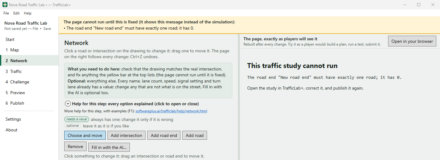
The yellow bar: here a road end was added but no road joins it yet. Click the line to go to that road end; add a road to it (or remove it) and the bar goes away. - Under each setting a line says where its value came from: from OpenStreetMap, from FDOT traffic counts, from the built-in example, suggested by the AI, typed by you, or a starting value — change it to match the real road.