The Map
The Map (1 Map on the left, or New study from the map on the start screen) turns real roads into a study, so you start with the real intersection instead of drawing it. The roads come from OpenStreetMap, a free map of the world made by volunteers, which records each road's lanes, turn lanes, speed limit and name, and where the traffic signals are.
The Map needs an internet connection. It is optional: a study made from an example or a layout skips it.
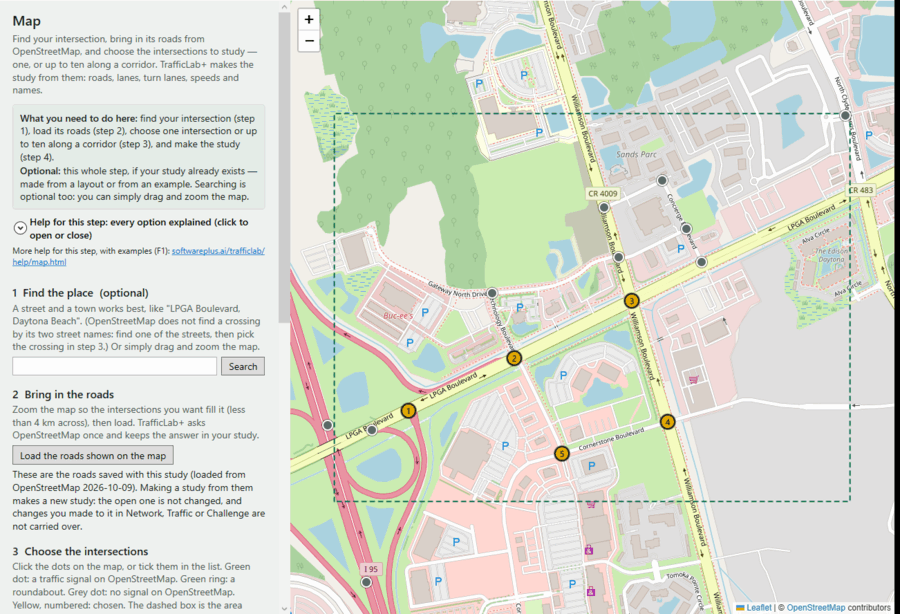
1 Find the place (optional)
- Type a street and a town, like LPGA Boulevard, Daytona Beach, and press Search (or Enter). A town alone works too.
- Click a result in the list to go there.
OpenStreetMap's search cannot find a crossing by its two street names ("LPGA & Williamson" finds nothing). Find one of the two streets, then pick the crossing in step 3. You can also skip the search: drag the map with the mouse, and zoom with the wheel or the + and − buttons.
2 Bring in the roads
- Zoom so the intersections you want fill the map, with a little room around them.
- Press Load the roads shown on the map. TrafficLab+ asks OpenStreetMap once for every road in the area shown. It takes a few seconds; then it says how many roads and intersections it found.
The area must be less than 4 km across (about the length of a ten-signal corridor). If it is bigger, the button is greyed out and the reason is written under it: zoom in. Roads that leave the loaded area stop at its edge, shown by a dashed box.
The answer is kept in your study file, so a saved study never asks OpenStreetMap again. Loading again replaces the roads and clears what you chose (you are asked first).
3 Choose the intersections
Every place two or more named roads meet is a dot:
- Green dot — a traffic signal on OpenStreetMap.
- Green ring — a roundabout.
- Grey dot — no signal on OpenStreetMap (it may be a stop sign, or the signal may simply not be mapped).
- Yellow, numbered — chosen.
Click a dot to choose it, and click again to un-choose it. Or tick it in the list; type part of a street name in Find by street name to shorten the list (this is how you find a crossing like LPGA Boulevard & Williamson Boulevard).
One intersection makes a single-intersection study. For a corridor, choose up to ten, in order along the main road: the numbers are the order. Use the ↑ and ↓ beside a chosen one to move it, and Remove to drop it. A divided road's crossing, which OpenStreetMap draws as four points close together, is treated as one intersection, so it has one dot.
4 Make the study
- Press Make the study from this intersection… (or …from these 5 intersections…).
- The A new traffic study window asks for the title (one is suggested), the place (filled in from your search), the budget players get, and the author and course. See Studies. Press Create the study.
- A message says what was made and lists things to check: an intersection with more than four roads (TrafficLab+ keeps the four busiest), a junction with no signal on OpenStreetMap (it starts as a signal), a road that ran off the loaded area. All of them are also kept in Challenge ▸ Your notes.
- The study opens in Network. What came from OpenStreetMap is marked from OpenStreetMap. What it could not know — the signal timing and the traffic — starts at a plain value marked a starting value. Set those in Network and Traffic, then save (Ctrl+S).
Opening a saved study and going to 1 Map shows the roads saved with it, without loading them again. Making a study from them makes a new study: the open one is not changed.
Credits
Map and roads © OpenStreetMap contributors (openstreetmap.org/copyright). Searches use Nominatim and roads come from Overpass — free services run by volunteers, which TrafficLab+ asks only when you press Search or Load. A page made from the map credits OpenStreetMap at the bottom. TrafficLab+ never uses Google Maps.