The network editor
2 Network is the network the page simulates: intersections (signals or roundabouts), the roads between them, and road ends — the edges of the study, where cars come in and go out. The drawing shows it from above; the form under the drawing shows the settings of whatever you choose. The page on the right is rebuilt about half a second after every change, so you can watch what each change does. The line above the page then says when (Rebuilt at 3:41:07 PM, after your change — a plan you were trying on the page starts again.): a plan you were trying on the page is cleared by each rebuild.
What you need to do here: check that the drawing matches the real intersection, and fix anything the yellow bar at the top lists. Everything else already has a value; change any that are not what is on the street.
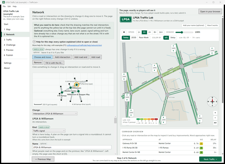
Reading the drawing
- Green dots are traffic signals, green rings are roundabouts, black squares are road ends.
- Roads are drawn wider when they have more lanes. Grid squares are 500 ft.
- What is chosen is ringed in yellow.
Choosing and moving
With Choose and move on, click an intersection, a road end or a road to choose it — or choose it from the Change: list under the drawing, which also works with the keyboard. Drag an intersection or a road end to move it; the roads follow. Moving changes only the drawing and the road lengths, not the names or settings. Drag the bar between the drawing and the form to give either more room.
Adding and removing
| Button | What it does |
|---|---|
| Add intersection | Click on the drawing where it goes. It starts as a traffic signal and needs 3 or 4 roads. |
| Add road end | Click where traffic should come in and leave — the edge of the study. |
| Add road | Click one intersection or road end, then another, to join them. A road end has exactly one road; an intersection at most four. |
| Remove | Removes what is chosen (or press Delete on the drawing). An intersection's roads go with it. |
| Fill in with the AI… | Optional: the AI proposes lanes, turn lanes, speeds and signal timing from what you tell it. See The AI. |
Press Esc, or click the active button again, to stop adding. Every change can be undone with Ctrl+Z.
An intersection's settings
| Setting | What it means |
|---|---|
| Kind | Traffic signal, Roundabout (one that exists today), or Road end (traffic enters and leaves). Players can turn a signal into a roundabout in their plan; they cannot turn a roundabout back. |
| Name, Short name | What players read on the page and the printout. The short name is used in the page's tables. |
| Cycle length | How many seconds the lights take to go all the way round, 40 to 180. Longer cycles move more cars each cycle but make each driver wait longer. |
| Main street's share of green | Of the green time, the percentage the main street gets (20 to 80%); the side street gets the rest. |
| Which roads are the main street | Tick the two roads that form the main street. If none are ticked, TrafficLab+ takes the two roads most opposite each other, widest first. |
| Protected left turns on the main street / side street today | A green-arrow phase for left turns. Without one, left turns wait for a gap in oncoming traffic. |
| Where it is | Distances east and south, in feet, from a corner of the drawing — easier to drag than to type. |
The signal timing is today's timing; players can retime a signal as part of their plan. A road end's settings are its traffic: Vehicles entering here and How busy as a destination (see Traffic).
A road's settings
| Setting | What it means |
|---|---|
| Street name | As people know it. Renaming a street renames it everywhere — every road with that name, and the intersections and road ends named after it — in one undo. |
| Through lanes in each direction | Lanes that carry traffic straight on, counted one way: 1, 2 or 3. Turn lanes are separate. A plan can add a lane each way. |
| Speed limit | The posted speed in mph; cars drive at about this speed on a clear road. |
| Show the street name on the page's map | Untick it for short pieces where the name would crowd the map. |
| Turn lanes that exist today | A short extra lane before a signal, so turning cars wait out of the way of through traffic — a left-turn and a right-turn lane for each direction arriving at a signal. These are free and part of today's network; players can buy more. |
A road's length comes from where its ends are: move an end to change it.
Needs a value, or optional
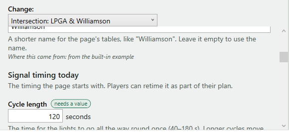
Beside the settings, a tag says needs a value (it always has one; change it only if it is wrong) or optional (leave it as it is if you like). Under each setting, a line in italics says where its value came from — for example Where this came from: from the built-in example, from OpenStreetMap, from FDOT traffic counts, suggested by the AI, typed by you, or a starting value (a guess to begin with: change it to match the real road if you know better). A value TrafficLab+ cannot accept (a cycle of 200 seconds, say) is refused with the reason beside the box, and nothing changes.